compulsory · CSS study notes
2. Process of Nature
📌
CSS GSA — Paper 7, Part-I, Section I, Sub-topic 2: Process of Nature
1. Hemispheres, Latitude, Longitude and Time
- Hemisphere: "half of a sphere"; Earth is divided into halves by imaginary lines, and there are three ways to split it
| Basis | Dividing line | The two halves | Pakistan lies in |
|---|---|---|---|
| By latitude | The Equator (0°) | Northern and Southern Hemisphere | Northern |
| By longitude | The Prime Meridian (0°) and the 180° meridian | Eastern and Western Hemisphere | Eastern |
| By land and water | No fixed line: the half with the most land or the most water | Land Hemisphere (centre near Nantes, France) and Water Hemisphere (centre near New Zealand) | — |
💡
In simple words: slice an orange along its middle and you get a north half and a south half; slice it from pole to pole and you get an east half and a west half. Pakistan is in the northern and eastern halves.
More detail on each hemisphere
- Northern / Southern Hemisphere
- Halves of Earth north and south of the Equator
- Also: Land Hemisphere and Water Hemisphere
- Land hemisphere is centred near Nantes, France
- Water hemisphere is centred near New Zealand
- Eastern / Western Hemisphere
- Split by the Prime Meridian (0°) and the 180° meridian
- Prime Meridian
- 0° longitude, passes through the Royal Observatory, Greenwich, England
- Reference line for Coordinated Universal Time (UTC), formerly GMT
1.1 Latitude (Parallels)
- What it is: imaginary circles running east–west, parallel to the Equator
- What it measures: distance north or south of the Equator, in degrees
- Starting line: the Equator = 0°
- Maximum: 90° N (North Pole) and 90° S (South Pole)
- They never meet, which is why they are called parallels; they get smaller towards the poles, so the Equator is the longest
- Why it matters: latitude decides how directly the Sun hits a place, so it controls climate
1.2 Longitude (Meridians)
- What it is: imaginary half-circles running north–south, from pole to pole
- What it measures: distance east or west of the Prime Meridian, in degrees
- Starting line: the Prime Meridian = 0° (Greenwich)
- Maximum: 180° E and 180° W, which are the same line (the 180° meridian)
- They meet (converge) at the poles, and all meridians are equal in length
- Why it matters: longitude sets the time
💡
In simple words: latitude lines are like the rungs of a ladder (they tell you how far up or down you are), and longitude lines are like the slices of an orange (they tell you how far left or right you are).
1.3 Latitude vs Longitude
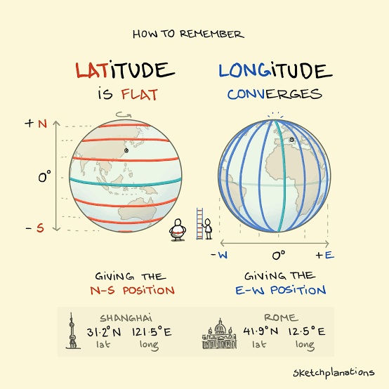
| Feature | Latitude (parallels) | Longitude (meridians) |
|---|---|---|
| Direction | East–west, parallel to the Equator | North–south, from pole to pole |
| Shape | Full circles that never meet | Half circles that meet at the poles |
| Measures | Distance north or south of the Equator | Distance east or west of the Prime Meridian |
| Starts at | Equator, 0° | Prime Meridian, 0° |
| Maximum | 90° N and 90° S | 180° E and 180° W |
| Length of each line | Shrinks towards the poles | All equal |
| Distance of 1° | ≈ 111 km everywhere | ≈ 111 km at the Equator, 0 km at the poles |
| Controls | Climate and seasons | Time |
1.4 Changes in Distance
- Latitude: 1° ≈ 111 km (69 miles) at every latitude, because the parallels are evenly spaced
- Longitude: 1° ≈ 111 km only at the Equator; it shrinks as the meridians squeeze together and becomes 0 km at the poles
| Latitude | 1° of longitude (km) | 1° of longitude (miles) |
|---|---|---|
| 0° (Equator) | 111 | 69 |
| 30° | 96 | 60 |
| 45° | 79 | 49 |
| 60° | 56 | 35 |
| 90° (poles) | 0 | 0 |
💡
MCQ clue: in the CSS 2024 question on one degree of longitude at the Equator, the wrong options 49 miles and 60 miles are the 45° and 30° values. The Equator value, 69 miles, is the answer.
1.5 Important Latitudes
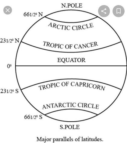
| Line | Latitude | What to remember |
|---|---|---|
| Arctic Circle | 66.5° N | Sun can stay up (or down) for 24 hours |
| Tropic of Cancer | 23.5° N | Sun is overhead at the June solstice |
| Equator | 0° | Longest parallel, ≈ 40,075 km around |
| Tropic of Capricorn | 23.5° S | Sun is overhead at the December solstice |
| Antarctic Circle | 66.5° S | Same as the Arctic Circle, in the south |
- Why 23.5° and 66.5°?
- The tropics sit at the same angle as Earth's axial tilt (NASA: 23.44°, rounded to 23.5° in textbooks)
- The polar circles sit at 90° minus the tilt
- Climate zones
- Torrid zone: between the two tropics
- Temperate zones: between a tropic and a polar circle
- Frigid zones: from a polar circle to the pole
- Pakistan lies roughly between 24° N and 37° N, and 61° E and 77° E
1.6 Countries on the Equator and the Prime Meridian
- Equator crosses 13 countries: Ecuador, Colombia, Brazil, São Tomé and Príncipe, Gabon, Republic of the Congo, Democratic Republic of the Congo, Uganda, Kenya, Somalia, Maldives, Indonesia and Kiribati
- Common trap: Peru, Venezuela and Tanzania are not on the list
- Prime Meridian passes through 8 countries: United Kingdom, France, Spain, Algeria, Mali, Burkina Faso, Togo and Ghana
- It also crosses Queen Maud Land in Antarctica
- It does not pass through Italy, Portugal or Germany
1.7 GMT, UTC and Time Zones
- GMT (Greenwich Mean Time): solar time at 0° longitude, the Prime Meridian
- UTC (Coordinated Universal Time): the atomic-clock standard that replaced GMT in 1972 as the world time standard
- Time zone: a region that uses the same local (standard) time
- The world has 24 standard zones of 15° each (real borders bend around countries)
- Pakistan Standard Time = UTC+5, based on the 75° E meridian
- The rule: Earth turns 360° in 24 hours, so 15° of longitude = 1 hour and 1° = 4 minutes
- Direction
- Travel east: clocks go ahead (plus hours)
- Travel west: clocks go behind (minus hours)
- Reason: Earth spins west to east, so the Sun reaches eastern places first
- International Date Line: runs roughly along 180°; crossing it westwards you add a day, crossing it eastwards you lose a day
- Worked examples
- 12 noon at Greenwich, at 75° E: 75 × 4 = 300 min = 5 h ahead, so 5:00 pm
- 12 noon at Greenwich, at 45° W: 45 × 4 = 180 min = 3 h behind, so 9:00 am
- Islamabad (≈ 73° E): sun time is 73 × 4 = 292 min (≈ 4 h 52 m) ahead of Greenwich, but clocks follow UTC+5
2. Earth's Movements
| Feature | Rotation | Revolution |
|---|---|---|
| Meaning | Earth spins on its axis, west → east | Earth orbits the Sun in an elliptical path |
| Time taken | ≈ 23 h 56 m 4 s (NASA: 23.9345 hours) | ≈ 365.256 days (365 d 6 h 9 m); the tropical year that sets the seasons is 365.242 days (≈ 365 d 5 h 48 m) |
| Also called | Daily motion | Annual motion |
| Main effects | Day and night; fixes a place's position; deflects winds and ocean currents (Coriolis effect) | Change of seasons (together with axial tilt) |
| Speed | ≈ 1,670 km/h at the Equator, 0 at the poles | ≈ 29.78 km/s (≈ 107,000 km/h) on average |
| Leap-year link | — | The extra ≈ ¼ day each year is why we add 29 February every 4 years |
- Axial tilt
- Earth's axis is tilted 23.5°
- That means ≈ 66.5° to the orbital plane
- NASA's current value is 23.44° (textbooks and MCQs round it to 23.5°)
- It swings between 22.1° and 24.5° over a ≈ 41,000-year cycle and is slowly decreasing
💡
In simple words: rotation gives us days, revolution plus the tilt gives us seasons.
2.1 Key Numbers (NASA Earth Fact Sheet)
| Quantity | Value |
|---|---|
| Equatorial radius | 6,378.137 km |
| Polar radius | 6,356.752 km (Earth bulges slightly at the Equator) |
| Mean radius | 6,371.0 km |
| Equatorial circumference | ≈ 40,075 km (calculated from the radius) |
| Rotation period (sidereal) | 23.9345 hours = 23 h 56 m 4 s |
| Orbital period | 365.256 days (sidereal); 365.242 days (tropical) |
| Mean distance from the Sun | ≈ 149.6 million km (1 AU) |
| Closest to the Sun (perihelion) | ≈ 147.1 million km, around 3 January |
| Farthest from the Sun (aphelion) | ≈ 152.1 million km, around 4 to 6 July |
| Orbital eccentricity | 0.0167 (almost a circle) |
| Axial tilt (obliquity) | 23.44° |
| Mean orbital speed | 29.78 km/s |
| Mass | 5.9722 × 10²⁴ kg |
💡
Seasons come from the tilt, not the distance. Earth is closest to the Sun in early January, when the Northern Hemisphere is having winter.
3. Equinoxes and Solstices
- Equinox
- Day and night are equal in length
- Sun is directly over the Equator
- ≈ 20–21 March: vernal (spring) equinox in the Northern Hemisphere
- ≈ 22–23 September: autumnal equinox in the Northern Hemisphere
- Seasons are reversed in the Southern Hemisphere
- Solstice
- Largest difference between day and night length
- Sun is directly over a tropic
3.1 Equinox vs Solstice (Types and Dates)
| Event | Meaning of the word | Sun is directly over | Day and night | Textbook date |
|---|---|---|---|---|
| Vernal (spring) equinox | "Equal night" | The Equator | Equal everywhere | 21 March |
| Summer solstice (June) | "Sun stands still" | Tropic of Cancer (23.5° N) | Longest day in the north, shortest in the south | 21 June |
| Autumnal equinox | "Equal night" | The Equator | Equal everywhere | 23 September |
| Winter solstice (December) | "Sun stands still" | Tropic of Capricorn (23.5° S) | Shortest day in the north, longest in the south | 22 December |
💡
In simple words: at an equinox the Sun is overhead at the Equator, so the whole world gets about 12 hours of day and 12 of night. At a solstice the Sun reaches its farthest point north or south and "turns back", so one hemisphere gets its longest day and the other its shortest. The seasons are opposite in the two hemispheres.
3.2 Solstices and Seasons
- June solstice (≈ 21 June)
- Sun is directly over the Tropic of Cancer (23.5° N)
- Longest day and start of summer in the Northern Hemisphere; shortest day in the Southern
- North of the Arctic Circle the Sun does not set (midnight Sun)
- December solstice (≈ 21–22 December)
- Sun is directly over the Tropic of Capricorn (23.5° S)
- Shortest day and start of winter in the north; longest day and start of summer in the south
- Textbook dates used in MCQs: 21 March, 21 June, 23 September, 22 December
3.3 Exact Dates for 2026
| Event | UTC | Pakistan time (UTC+5) |
|---|---|---|
| March equinox | 20 Mar 2026, 14:47 | 20 Mar, 19:47 |
| June solstice | 21 Jun 2026, 08:25 | 21 Jun, 13:25 |
| September equinox | 23 Sep 2026, 00:06 | 23 Sep, 05:06 |
| December solstice | 21 Dec 2026, 20:51 | 22 Dec, 01:51 |
ℹ️
The real dates move by a day or so from year to year because a calendar year is not exactly 365 days. Times come from the NASA/JPL ephemeris (DE405). For MCQs, still use the textbook answer: 21 March and 23 September.
4. Eclipses
| Feature | Lunar Eclipse | Solar Eclipse |
|---|---|---|
| What happens | Earth passes between Sun and Moon; Earth's shadow falls on the Moon | Moon passes between Sun and Earth, blocking sunlight |
| Moon phase | Only at Full Moon | Only at New Moon |
| Does it happen every time? | No, not at every full moon | No, not at every new moon (because of the Moon's orbital inclination) |
| Types | Total, partial or penumbral | Total, partial or annular (rare hybrid too) |
| Seen from | Anywhere on the night side of Earth | Only a narrow strip of Earth (the path of totality) |
| How long | Total phase up to ≈ 1 h 47 m (59 min on 3 Mar 2026); whole umbral eclipse ≈ 3 to 4 h | Totality at most ≈ 7.5 min, usually 2 to 4 min |
| How often | About 2 a year | 2 to 5 a year somewhere on Earth; a total one every 1 to 2 years (≈ 18 months) |
4.1 Types of Eclipse
| Eclipse | Type | Meaning | What you see |
|---|---|---|---|
| Solar (new moon) | Total | The Moon fully covers the Sun | Day turns dark and the Sun's corona shows |
| Solar (new moon) | Partial | The Moon covers only part of the Sun | A bite taken out of the Sun |
| Solar (new moon) | Annular | The Moon is too far away to cover the Sun fully | A bright "ring of fire" around the Moon |
| Solar (new moon) | Hybrid | Changes between annular and total along its path | Rare |
| Lunar (full moon) | Total | The whole Moon enters Earth's dark shadow (umbra) | The Moon turns coppery red ("blood moon") |
| Lunar (full moon) | Partial | Only part of the Moon enters the umbra | A dark "bite" on the Moon |
| Lunar (full moon) | Penumbral | The Moon passes only through the faint outer shadow | A subtle dimming, easy to miss |
💡
In simple words: a solar eclipse is the Moon hiding the Sun; a lunar eclipse is the Earth's shadow darkening the Moon.
4.2 Eclipse Facts (NASA)
- Alignment: a solar eclipse needs a new moon; a lunar eclipse needs a full moon
- Why not every month: the Moon's orbit is tilted ≈ 5° to Earth's orbit, so eclipses happen only near the two crossing points
- This gives two eclipse seasons a year, about 173 days apart
- Number per year: at least 2 solar eclipses and at most 5; a year has 4 to 7 eclipses in all
- Saros cycle: nearly identical eclipses repeat every 18 years 11 days (6,585.32 days)
- Shadows
- Umbra: the darkest part of the shadow (totality)
- Penumbra: the lighter outer part (partial eclipse)
- Annular eclipse: Moon is far from Earth, so a bright ring of Sun shows around it
- Safety: never look at a solar eclipse without eclipse glasses; a lunar eclipse is safe to watch
4.3 Recent and Upcoming Eclipses (NASA)
| Date | Type | Where seen |
|---|---|---|
| 8 Apr 2024 | Total solar | Mexico, USA, Canada (up to 4 m 28 s) |
| 17 Feb 2026 | Annular solar | Antarctica (partial in parts of Africa and South America) |
| 3 Mar 2026 | Total lunar | Asia, Australia, Pacific, Americas |
| 12 Aug 2026 | Total solar | Greenland, Iceland, Spain (partial across Europe, Africa, North America) |
| 27–28 Aug 2026 | Partial lunar | Americas, Europe, Africa, western Asia |
| 6 Feb 2027 | Annular solar | South America and Africa |
| 2 Aug 2027 | Total solar | Southern Spain, North Africa, Saudi Arabia, Yemen (totality up to ≈ 6 m 23 s) |
5. Weather vs Climate
- Weather
- Atmospheric conditions at a specific time and place
- Changes daily
- Climate
- Average weather conditions over a long period
- The "expected" benchmark
💡
Quick way to remember: weather is what it is NOW; climate is what it SHOULD BE.
5.1 Weather vs Climate at a Glance
| Basis | Weather | Climate |
|---|---|---|
| Meaning | Everyday condition of the atmosphere in a place | Average atmospheric conditions over a long period |
| Time span | Minutes to days | Usually 30 years (the WMO standard period is now 1991–2020) |
| Variation | Changes constantly | Changes very slowly |
| Main elements | Temperature, humidity, pressure, cloudiness, precipitation, wind | Mainly temperature and precipitation |
| Studied by | Meteorology | Climatology |
6. Elements of Weather and Climate
| Element | As weather | As climate | Measured by |
|---|---|---|---|
| Temperature | Hotness/coldness now | Long-term average | Thermometer (°C or °F) |
| Precipitation | Rain/snow/hail event | Long-term average pattern | Rain gauge (mm) |
| Air Pressure | Daily high/low systems | Long-term average pattern | Barometer (mb/hPa) |
| Wind | Daily/hourly direction and speed | Long-term average direction and strength | Wind vane (direction), Anemometer (speed; km/h, m/s or knots) |
| Sunshine | Direct sunlight received | — | Campbell-Stokes recorder |
| Cloudiness | Sky covered by clouds (in oktas: 0 = clear, 8 = overcast) | — | Nephoscope (also tracks cloud movement) |
| Humidity | Water vapour in the air right now | Long-term average | Hygrometer or psychrometer |
- How many elements?
- The standard list of six: temperature, precipitation, humidity, cloudiness, air pressure and wind
- Sunshine is often added as an extra (seventh) element
- Pressure and weather
- High pressure → clear, dry weather
- Low pressure → cloudy, rainy, stormy weather
- Wind direction rule: wind always blows from high pressure to low pressure
7. Climate-Controlling Factors
- Two groups of factors
- Temperature factors: latitude, altitude, distance to a body of water, ocean currents
- Precipitation factors: topography, prevailing winds
- Latitude
- The single most significant climate factor
- Warmer at the equator, colder at the poles
- Seasons are reversed between hemispheres
- Altitude
- Temperature (and often precipitation) decreases as altitude increases
- Average fall: 6.5 °C per 1,000 m (about 1 °C for every 150 m)
- Some textbook diagrams (like the Ben Nevis example) simplify this to about 1 °C per 100 m
- Distance from large water bodies
- Near water: moderate temperatures, smaller annual range, higher humidity and rainfall
- Far from water: extreme temperatures, larger annual range, lower rainfall
- Ocean currents
- What they are: continuous, directed flow of seawater driven by wind, the Coriolis effect, gravity and water density
- Warm currents: raise coastal temperature, humidity and rainfall
- Cold currents: lower temperature, reduce rainfall (can create coastal deserts)
- Examples
- Warm: Gulf Stream and North Atlantic Drift (keep north-west Europe mild), Kuroshio near Japan
- Cold: Humboldt (Peru) Current beside the Atacama Desert, Benguela Current beside the Namib Desert, Labrador Current
- Topography
- Windward side of a mountain range is wetter
- Leeward side is drier
- This is the rain shadow effect
- Prevailing winds
- The winds that blow most often at a place
- Winds blowing over tropical oceans bring warm, wet weather
- Winds blowing from the poles or over land bring cold, dry weather
- Plate tectonics
- Over millions of years, moving continents change the land–sea layout, mountain ranges and ocean currents, so they change climate
- Volcanic eruptions
- Emit CO₂ (warming)
- Also emit SO₂/aerosols that reflect sunlight (cooling)
- So they can do both
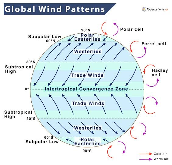
7.1 Climate Factors at a Glance
| Factor | Group | Effect | Example |
|---|---|---|---|
| Latitude | Temperature | Warm near the Equator, cold near the poles | Torrid zone vs frigid zone |
| Altitude | Temperature | Falls about 6.5 °C per 1,000 m | Murree is cooler than Lahore |
| Distance from water | Temperature (and rainfall) | Coasts are mild and humid; interiors are extreme and drier | Karachi (coast) vs Jacobabad (interior) |
| Ocean currents | Temperature (and rainfall) | Warm currents warm and wet the coast; cold currents cool and dry it | Humboldt Current and the Atacama Desert |
| Topography | Precipitation | Windward slopes are wet, leeward slopes dry (rain shadow) | Himalaya's southern slopes vs the dry Tibetan Plateau |
| Prevailing winds | Precipitation | Sea winds bring moisture, land winds bring dry air | Summer monsoon winds bring Pakistan's rain |
💡
In simple words: where you are on the globe (latitude), how high you are (altitude), how close the sea is, and which way the wind blows decide whether a place is hot, cold, wet or dry.
8. World Climate Classification
- Ancient Greeks: divided each hemisphere into Torrid, Temperate, Frigid zones
- Torrid zone: between the tropics (23.5° N to 23.5° S), the hottest
- Temperate zone: 23.5° to 66.5° in each hemisphere, moderate
- Frigid zone: 66.5° to 90° in each hemisphere, the coldest
- Köppen Classification
- By Vladimir Köppen (1846–1940)
- Most widely used climate classification
- Based on monthly/annual temperature and precipitation data
- Boundaries linked to natural vegetation limits
| Group | Name | Key feature |
|---|---|---|
| A | Tropical / Megathermal | Constantly warm |
| B | Dry / Arid | Low precipitation |
| C | Temperate / Mesothermal | Mild annual temperature |
| D | Continental / Microthermal | Hot summers, cold winters (continental interiors) |
| E | Polar / Alpine | Consistently cold |
- Note: groups A, C, D, E are defined by temperature; group B by aridity
- Köppen's scheme was later modified by Rudolf Geiger, so it is also called Köppen–Geiger
8.1 Tropics, Subtropics and Temperate Zone
- Tropics: the belt around the middle of the globe, between the Tropic of Cancer and the Tropic of Capricorn (23.5° N to 23.5° S)
- Subtropical climates: hot summers and mild winters, with frost being rare
- Temperate zone: warm summers, cold winters, and moderate spring and autumn
8.2 Main Köppen Climate Types
| Code | Name | Key feature | Example region |
|---|---|---|---|
| Af | Tropical rainforest | Hot and wet all year | Amazon, Congo, Indonesia |
| Am | Tropical monsoon | Heavy rain with a short dry season | Parts of South and Southeast Asia |
| Aw | Tropical savanna | Wet summer, dry winter | African savannas |
| BWh | Hot desert | Very dry and hot | Sahara, Arabian Desert, Thar |
| BSh | Hot semi-arid (steppe) | Dry, but with a little rain | Sahel, parts of the Indus plains |
| Cs | Mediterranean | Hot dry summers, mild wet winters | Mediterranean coast, California |
| Cfa / Cwa | Humid subtropical | Hot humid summers, mild winters | Eastern USA, southern China, parts of north India |
| Cfb | Marine west coast | Mild all year, rain all year | UK, western Europe |
| Df | Humid continental / subarctic | Cold winters, warm short summers | Russia, Canada |
| ET | Tundra | Warmest month stays between 0 and 10 °C | Arctic fringe |
| EF | Ice cap | Always below 0 °C | Antarctica, Greenland |
- How to read the code: first letter = main group (A to E); second letter = rainfall pattern (f = no dry season, m = monsoon, w = dry winter, s = dry summer, W = desert, S = steppe); third letter = summer heat (h = hot, a = hot summer, b = warm summer, c = cool summer, k = cold)
- Pakistan: most of the country is arid or semi-arid (group B); the northern mountains are much colder
9. Weather Variables in Detail
📋
The syllabus asks for global temperature, pressure, circulation, precipitation, humidity and weather variations. Sections 5–7 above cover the basics; this section gives each variable in full.
9.1 Global Temperature
- Source: insolation (incoming solar radiation); Earth's average surface temperature is about 15 °C
- Pattern: warmest near the equator, falling towards the poles; isotherms are lines joining places of equal temperature
- Normal lapse rate: temperature falls about 6.5 °C per 1,000 m of height
- Temperature inversion: a layer where temperature rises with height (cold, calm winter nights); it traps fog and smog near the ground, as in Punjab's winter smog
- Land vs water: land heats and cools faster than sea, so coasts are milder than interiors
- Trend (NASA)
- 2024 is the warmest year on record since 1880
- 2025 was effectively tied with 2023 as the second warmest, about 1.19 °C above the 1951–1980 average
- 2025, 2024 and 2023 are the three warmest years in NASA's 146-year record
9.2 Atmospheric Pressure
- Pressure: the weight of the air column above a place; measured by a barometer in millibars (mb) or hectopascals (hPa)
- Standard sea-level pressure: about 1,013 hPa; it falls with height
- Isobars: lines of equal pressure; close isobars mean strong winds
| Feature | High pressure (anticyclone) | Low pressure (cyclone) |
|---|---|---|
| Air movement | Sinks | Rises |
| Weather | Clear, dry | Cloudy, rainy, stormy |
| Wind spiral (Northern Hemisphere) | Outward, clockwise | Inward, counterclockwise |
9.3 Global Circulation (Pressure Belts and Winds)
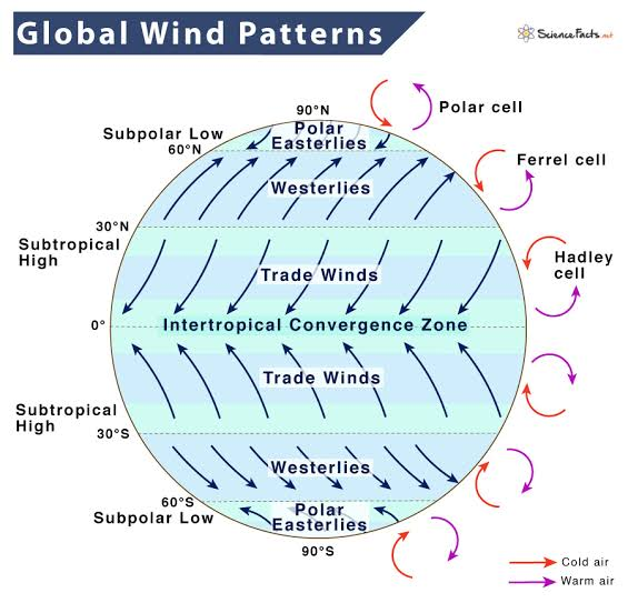
| Belt | Latitude | Features |
|---|---|---|
| Equatorial low (ITCZ, doldrums) | ≈ 0° | Hot air rises; heavy rain; light winds |
| Subtropical highs | ≈ 30° N and S | Air sinks; dry; great deserts |
| Subpolar lows | ≈ 60° N and S | Warm and cold air meet; stormy |
| Polar highs | ≈ 90° | Cold air sinks |
- Wind belts: trade winds (from 30° towards the equator, blowing east → west), westerlies (30° to 60°, west → east), polar easterlies
- Three-cell model: Hadley cell (0–30°), Ferrel cell (30–60°), Polar cell (60–90°)
- Coriolis effect: Earth's rotation bends winds to the right in the Northern Hemisphere and to the left in the Southern
- Jet streams: narrow, very fast west-to-east winds near the top of the troposphere
- Monsoon: seasonal wind reversal; in summer the land heats, a low forms, and moist winds blow in from the sea; the South Asian summer monsoon (June–September) brings most of Pakistan's rain, while western disturbances bring winter rain to the north
- Sea and land breezes: sea breeze by day (sea → land), land breeze by night
9.4 Humidity
| Term | Meaning |
|---|---|
| Absolute humidity | Mass of water vapour per cubic metre of air (g/m³) |
| Specific humidity | Mass of water vapour per kilogram of air |
| Relative humidity (RH) | Vapour present ÷ maximum the air can hold at that temperature × 100 (shown in %) |
- Warm air holds more vapour than cold air
- Dew point: the temperature at which air becomes saturated (RH = 100%); below it, vapour condenses as dew, fog or cloud
- Instruments: hygrometer or psychrometer (wet and dry bulb thermometers)
- Effect: hot and humid weather feels hotter because sweat evaporates slowly
9.5 Precipitation
- Precipitation: water falling from clouds as rain, drizzle, snow, sleet or hail
- How it forms: moist air rises and cools, vapour condenses on tiny particles into cloud droplets, the droplets join (and ice crystals grow in cold clouds) until they are heavy enough to fall
| Type | Cause | Where/when |
|---|---|---|
| Convectional | Ground heating makes warm, moist air rise | Tropics; summer afternoons; thunderstorms |
| Orographic (relief) | Air forced up a mountain | Windward slopes wet; leeward side in rain shadow |
| Frontal (cyclonic) | Warm air rises over cold air at a front | Middle latitudes |
- Measured by: a rain gauge in millimetres
| Form | What it is | How it forms |
|---|---|---|
| Drizzle | Very fine droplets (under 0.5 mm) | From low, flat stratus cloud |
| Rain | Liquid drops of 0.5 mm or more | Cloud droplets join until they are heavy enough to fall |
| Snow | Ice crystals (flakes) | When the air all the way down is below freezing |
| Sleet | Frozen or half-melted raindrops | Snow melts as it falls, then refreezes near the ground |
| Hail | Balls of layered ice | Grow as strong updrafts toss them up and down inside a thunderstorm (cumulonimbus) cloud |
- Not precipitation: dew, frost, mist and fog are condensation at or near the ground
9.6 Weather Variations
- Causes: day–night and seasonal changes in the Sun's angle, moving air masses, fronts and pressure systems
- Air mass: a large body of air with fairly uniform temperature and humidity
| Front | What happens | Weather |
|---|---|---|
| Warm front | Warm air slowly rises over cold air | Steady, light rain, then warmer |
| Cold front | Cold air pushes under warm air | Heavy showers, thunder, then colder and clear |
| Occluded front | Cold front overtakes a warm front | Mixed, long rainy spell |
- Forecasting: weather stations, balloons, radar and satellites feed computer models; the Pakistan Meteorological Department (PMD) issues forecasts and warnings
- Extremes such as heatwaves and floods are becoming more frequent with climate change
9.7 Types of Winds
| Class | Meaning | Examples |
|---|---|---|
| Planetary (permanent) | Blow all year in the same direction over large areas, driven by the pressure belts | Trade winds, westerlies, polar easterlies |
| Periodic | Change with the season or the time of day | Monsoon; sea and land breezes; mountain and valley breezes |
| Local | Blow over small areas because of local heating or terrain | Loo (hot, dry summer wind of the Pakistan and north India plains), Chinook (warm wind east of the Rockies), Föhn (Alps), Mistral (cold wind in southern France), Sirocco (hot wind from the Sahara), Harmattan (dry, dusty wind in West Africa) |
- Beaufort scale: rates wind force from 0 (calm) to 12 (hurricane force)
💡
In simple words: the Loo is the "hair-dryer" wind of Punjab and Sindh in May and June; the monsoon is the wind that changes direction with the season and brings the rain.
9.8 Clouds
- Cloud: a visible mass of tiny water droplets or ice crystals floating in the air; it forms when rising air cools and its vapour condenses
- Name roots: cirrus = curl (wispy), cumulus = heap (puffy), stratus = layer (flat), nimbus = rain-bearing
| Group | Height (approx.) | Types | Weather clue |
|---|---|---|---|
| High | Above 6 km | Cirrus, cirrocumulus, cirrostratus | Made of ice crystals; thin and wispy; may signal an approaching front |
| Middle | 2 to 6 km | Altocumulus, altostratus | Grey patches or sheets; rain may follow |
| Low | Below 2 km | Stratus, stratocumulus, nimbostratus | Grey and flat; stratus gives drizzle, nimbostratus gives steady rain |
| Vertical (tall) | Low base, very high top | Cumulus, cumulonimbus | Cumulus = fair-weather puffs; cumulonimbus = thunderstorm, heavy rain, hail |
9.9 Types of Air Masses
- Air mass: a large body of air with fairly uniform temperature and humidity, taking on the character of the region where it formed
| Air mass | Symbol | Source region | Weather it brings |
|---|---|---|---|
| Continental Arctic | cA | Arctic land and ice | Extremely cold and dry |
| Continental Polar | cP | Cold northern land (e.g. Siberia) | Cold and dry; cold waves |
| Maritime Polar | mP | Cold oceans | Cool and moist, cloudy |
| Continental Tropical | cT | Hot deserts | Hot and dry |
| Maritime Tropical | mT | Warm tropical oceans | Warm, humid, heavy rain |
- How to read the symbols: c = continental (dry), m = maritime (moist); A, P, T = Arctic, Polar, Tropical
🌡️ Mirage — CSS 2017: step-by-step explanation
- Definition: An optical illusion in which distant sky or objects look like reflections or water due to changing refractive index in air layers of different temperatures.
- Cause: On a hot road, air immediately above the surface is hotter and less dense than cooler air above it; light bends continuously through these layers.
- Formation: Light from the sky travels downward → passes through progressively hotter air → bends away from the normal as refractive index decreases → bends upward toward an observer → the brain extends the ray backward, creating a false image of the sky on the road.
- Types: Inferior mirage (image below object, hot ground) and superior mirage (image above object, temperature inversion over cold surface).
- Exam tip: A mirage is primarily refraction through a refractive-index gradient, not ordinary reflection from a real puddle.
🌐 Weather mechanisms often needed for explanatory answers
- Atmospheric pressure decreases with altitude: Less air above means less overlying weight; warm rising air often supports low pressure near the surface.
- Coriolis effect: Earth's rotation deflects freely moving air to the right in the Northern Hemisphere and left in the Southern Hemisphere; zero at the equator, strongest near poles.
- Rain shadow: Moist air rises along a mountain, cools and condenses on the windward side; descending leeward air warms, reducing relative humidity and rainfall.
- Relative humidity (RH): Actual water-vapour content relative to saturation at the same temperature, expressed as a percentage; warming air without adding moisture generally reduces RH.
- Seasonal contrast: Earth's 23.4° axial tilt, not changing Earth–Sun distance, is the dominant cause of seasons.
- Local time: About 15° longitude = 1 hour of solar-time difference; east is ahead, west behind. One degree longitude is not always 111 km: it decreases poleward approximately with cosine(latitude).
10. MCQ Traps
🚨
- Solar eclipse occurs at New Moon; lunar eclipse at Full Moon (commonly reversed in MCQs)
- Weather changes daily; climate is the long-term average, so don't confuse the two
- Windward side of a mountain is wetter; leeward side is drier (rain shadow)
- Latitude, not altitude, is the single most significant climate factor
- Seasons come from the axial tilt, not from Earth's distance from the Sun (Earth is closest to the Sun in early January)
- 1° of latitude is about 111 km everywhere; 1° of longitude is about 111 km only at the Equator and shrinks to 0 km at the poles
- 15° of longitude = 1 hour = 4 minutes per degree; places to the east are ahead of Greenwich and places to the west are behind
- Tropics at 23.5°, polar circles at 66.5° (not the other way round)
- The Prime Meridian does not pass through Italy, Portugal or Germany; it passes through the UK, France, Spain, Algeria, Mali, Burkina Faso, Togo and Ghana
- UTC replaced GMT as the world time standard in 1972
- A total solar eclipse needs a new moon; a year has at most 5 solar eclipses
- Equinox = equal day and night (Sun over the Equator); solstice = longest or shortest day (Sun over a tropic)
- Nimbostratus brings steady rain; cumulonimbus is the thunderstorm cloud; cirrus is high and wispy
- The Loo is a hot, dry local wind; the monsoon is a seasonal wind reversal
- Hail (layered ice from thunderclouds) is not the same as sleet; dew and fog are not precipitation
- In an annular eclipse the Moon is too far to cover the Sun fully (ring of fire); a penumbral lunar eclipse is a faint dimming
11. Self-Test Questions
- Differentiate between rotation and revolution, and state one effect of each.
- Explain why a solar eclipse occurs only at new moon and a lunar eclipse only at full moon.
- List the six elements of weather and climate and how each is measured.
- Explain the rain shadow effect.
- Name and briefly describe Köppen's five climate groups.
- Differentiate between latitude and longitude, and explain why 1° of longitude is not the same distance everywhere.
- Explain how longitude is used to calculate time, with one worked example.
- State NASA's values for Earth's rotation period, orbital period and axial tilt.
- Classify clouds by height, with the main types and the weather each brings.
- Classify winds into planetary, periodic and local, with examples of each.
- Differentiate between an equinox and a solstice, and name the four events with their dates.
- Describe the types of solar and lunar eclipse.
12. Past-Paper MCQs (FPSC)
✅
Taken from the FPSC papers you shared (2015–2025). FPSC does not publish MCQ keys, so the answers are worked out by me.
- (CSS 2024, Q1.2) When day and night are equal? (A) 23rd February and 21st September (B) 21st March and 23rd September (C) 23rd March and 21st September (D) None of these
- (CSS 2024, Q1.6) One degree of longitude on the equator is equal to a distance of: (A) 49 miles (B) 69 miles (C) 39 miles (D) 60 miles
- (CSS 2025, Q1.4) Global winds towards western direction are known as: (A) Trade winds (B) Western winds (C) Reynolds wind (D) None of these
- ✅ Answer key
- (B) 21st March and 23rd September (the equinoxes; the real dates can shift by a day, e.g. 20 March, but this is the standard textbook answer)
- (B) 69 miles (≈ 111 km)
- (A) Trade winds (they blow from east to west, i.e. towards the west; the Westerlies blow the opposite way)
13. Past-Paper Long Questions with Answers (FPSC)
✅
Every question below appeared in the FPSC papers you shared; the year and question number are in each title. Answers are model outlines written by me, ready to expand.
-
CSS 2015 Q3(a), 2017 Q4(B), 2018 Q2(B): How are solar and lunar eclipses caused? Differentiate between their occurrence. Explain the formation of a lunar eclipse. (5)
Feature Lunar Eclipse Solar Eclipse Alignment Sun → Earth → Moon Sun → Moon → Earth What happens Earth's shadow falls on the Moon Moon blocks sunlight from reaching Earth Moon phase Only at Full Moon Only at New Moon Types Total, partial, penumbral Total, partial, annular Seen from Anywhere on the night side of Earth Only a narrow path on Earth Duration Can last a couple of hours Totality lasts only a few minutes - Why not every month: the Moon's orbit is tilted ≈ 5° to Earth's orbit, so the three bodies line up exactly only at certain times
- Formation of a lunar eclipse: the Moon passes into Earth's umbra (dark shadow) and penumbra (partial shadow); in a total eclipse it often looks red because Earth's atmosphere bends sunlight onto it
-
CSS 2017 Q4(C), 2025 Q2(a): What effects are produced due to Rotation and Revolution of Earth? (5)
Feature Rotation Revolution Meaning Spin on its axis, west → east, in ≈ 23 h 56 m 4 s Orbit around the Sun in ≈ 365¼ days Effects Day and night; fixes a place's time and position; deflection of winds and ocean currents (Coriolis effect); daily rise and fall of tides; slight bulging at the equator Change of seasons (with the 23.5° axial tilt); changing length of day and night through the year; equinoxes and solstices; different constellations visible in different seasons - Key link: without the axial tilt, revolution alone would not give seasons
-
CSS 2020 Q2(b): What do you understand by Global Wind and Pressure patterns? Also explain wind and pressure features at higher altitude. (5)
- Global pressure belts (caused by uneven heating of Earth)
- Equatorial low (doldrums): hot air rises
- Subtropical highs (≈ 30° N and S): air sinks, dry
- Subpolar lows (≈ 60° N and S)
- Polar highs: cold air sinks
- Global wind belts (wind blows from high to low pressure, bent by the Coriolis effect: to the right in the Northern Hemisphere, to the left in the Southern)
- Trade winds: from the subtropical highs towards the equator, blowing east → west
- Westerlies: from the subtropical highs towards 60°, blowing west → east
- Polar easterlies: from the polar highs towards 60°
- At higher altitude
- Air pressure falls with height
- Winds are faster and steadier because there is no surface friction
- Winds follow lines of equal pressure (geostrophic flow)
- Jet streams: narrow, very fast west-to-east winds near the top of the troposphere (≈ 9–12 km)
- Global pressure belts (caused by uneven heating of Earth)
-
CSS 2022 Q2(d): Discuss various factors which affect the variations in the climate of a place. (5)
- Temperature factors
- Latitude: the most significant factor; warmer at the equator, colder at the poles
- Altitude: temperature falls as height increases
- Distance from water: near water means moderate temperatures and higher rainfall; far from water means extremes and less rain
- Ocean currents: warm currents raise coastal temperature and rainfall; cold currents lower them (coastal deserts)
- Precipitation factors
- Topography: windward side wetter, leeward side drier (rain shadow)
- Prevailing winds: bring moisture from the sea or dry air from land
- Other factors: volcanic eruptions (CO₂ warming vs aerosol cooling), vegetation cover and human activity
- Temperature factors
14. Extra Practice MCQs (exam-style, not official)
ℹ️
These are exam-style practice questions written by me, not copied from FPSC papers. The official past-paper MCQs are in the section above.
- A solar eclipse occurs at: (a) Full Moon (b) New Moon (c) First quarter (d) Last quarter
- The Prime Meridian passes through: (a) Paris (b) Greenwich (c) Cairo (d) Rome
- Air pressure is measured by a: (a) Thermometer (b) Anemometer (c) Barometer (d) Nephoscope
- Wind speed is measured by an: (a) Anemometer (b) Wind vane (c) Rain gauge (d) Barometer
- On the equinox: (a) Day is longest (b) Night is longest (c) Day and night are equal (d) The Sun is over the Tropic of Cancer
- In the Köppen system, group B represents: (a) Tropical (b) Dry (c) Temperate (d) Polar
- The single most significant factor controlling climate is: (a) Altitude (b) Latitude (c) Ocean currents (d) Topography
- The leeward side of a mountain range is generally: (a) Wetter (b) Drier (c) Colder only (d) Unaffected
- The tilt of Earth's axis is: (a) 10° (b) 23.5° (c) 45° (d) 66.5° from the vertical
- Cloud cover is measured in: (a) Millibars (b) Oktas (c) Millimetres (d) Kelvin
- Earth completes one rotation in about: (a) 24 hours exactly (b) 23 h 56 m 4 s (c) 365 days (d) 27 days
- Every 15° of longitude makes a time difference of: (a) 1 minute (b) 4 minutes (c) 1 hour (d) 24 hours
- The Prime Meridian does NOT pass through: (a) Ghana (b) Spain (c) Italy (d) Algeria
- One degree of longitude at the poles equals: (a) 111 km (b) 79 km (c) 11 km (d) 0 km
- The Arctic Circle lies at: (a) 23.5° N (b) 45° N (c) 66.5° N (d) 90° N
- The Equator does NOT cross: (a) Kenya (b) Brazil (c) Peru (d) Gabon
- When it is 12 noon at Greenwich, the time at 75° E (UTC+5, Pakistan) is: (a) 7 am (b) 5 pm (c) 12 noon (d) 5 am
- Earth is closest to the Sun (perihelion) in: (a) January (b) April (c) July (d) October
- According to NASA, the maximum number of solar eclipses in one year is: (a) 2 (b) 3 (c) 5 (d) 7
- UTC replaced GMT as the world time standard in: (a) 1884 (b) 1945 (c) 1972 (d) 2000
- Which cloud brings steady rain? (a) Cirrus (b) Nimbostratus (c) Altocumulus (d) Cumulus
- The Loo is a: (a) cold sea wind (b) hot, dry local wind (c) monsoon wind (d) polar wind
- The tall clouds that produce thunderstorms and hail are: (a) Stratus (b) Cirrus (c) Cumulonimbus (d) Altostratus
- In Köppen's system the code BWh stands for: (a) tropical rainforest (b) hot desert (c) Mediterranean (d) tundra
- At the June solstice the Sun is directly over the: (a) Equator (b) Tropic of Capricorn (c) Tropic of Cancer (d) Arctic Circle
- An annular solar eclipse shows: (a) total darkness (b) a ring of fire (c) a red Moon (d) no change
- ✅ Answer key
- (b) New Moon (lunar eclipse = Full Moon)
- (b) Greenwich
- (c) Barometer
- (a) Anemometer (wind vane gives direction)
- (c) Day and night are equal
- (b) Dry (arid)
- (b) Latitude
- (b) Drier (rain shadow)
- (b) 23.5° (≈ 66.5° to the orbital plane)
- (b) Oktas (0 = clear, 8 = overcast)
- (b) 23 h 56 m 4 s
- (c) 1 hour (so 1° = 4 minutes)
- (c) Italy (the line crosses the UK, France, Spain, Algeria, Mali, Burkina Faso, Togo and Ghana)
- (d) 0 km (the meridians meet at the poles; the lecture slide's "11 km" is a mistake)
- (c) 66.5° N
- (c) Peru
- (b) 5 pm (75 × 4 = 300 min = 5 h ahead)
- (a) January (around 3 January)
- (c) 5
- (c) 1972 (1884 is when Greenwich was chosen as the Prime Meridian)
- (b) Nimbostratus (cumulonimbus gives thunderstorms and hail)
- (b) Hot, dry local wind of the northern plains in summer
- (c) Cumulonimbus
- (b) Hot desert (B = dry, W = desert, h = hot)
- (c) Tropic of Cancer (23.5° N)
- (b) A ring of fire (the Moon is too far to cover the Sun fully)
15. Extra Practice Long Questions (20 Marks)
ℹ️
Extra practice questions built from the syllabus. The official past-paper questions with answers are in the section above.
- Differentiate between rotation and revolution of the Earth, and explain their effects
- Explain why a solar eclipse occurs only at new moon and a lunar eclipse only at full moon
- Differentiate between weather and climate, and discuss the elements of weather and climate with their instruments
- Discuss the factors that control climate
- Explain the rain shadow effect with an example
- Describe Köppen's classification of world climates
- Differentiate between latitude and longitude, and explain how longitude helps calculate time
- Write a note on the Equator, the Prime Meridian and the important parallels of latitude
- Classify clouds and winds, with examples of each type
- 📝 Answer outlines
- Table of rotation vs revolution → effects (day/night, Coriolis; seasons with tilt) → note on tilt 23.5°
- Table of lunar vs solar eclipse → alignment (Sun-Earth-Moon) → why not every month (orbital inclination)
- Definitions → quick distinction (NOW vs SHOULD BE) → six-element table with instruments
- Temperature factors (latitude, altitude, water, currents) → Precipitation factors (topography, winds) → volcanic eruptions
- Windward wetter, leeward drier → moist air rises, cools, rains, then descends dry
- Five groups A–E table → note A, C, D, E by temperature; B by aridity
- Comparison table (direction, measures, start line, maximum, value of 1°, controls) → 15° = 1 hour rule → worked example
- Equator (0°, 13 countries) → Prime Meridian (0°, Greenwich, 8 countries) → tropics at 23.5° and polar circles at 66.5° → the three climate zones
- Cloud definition → table (high, middle, low, vertical; types; weather clue) → name roots → winds: planetary, periodic, local with examples (Loo, Chinook, Mistral) → Beaufort scale
16. Book Questions: Added Answers
📖
Answers for the book's contents-list questions (Part A, I.b) that were missing or thin on this page. Each answer starts with a written outline, then headings and bullets.
- Book p.11 (CSS 2017 Q4(A)): What is a mirage? Describe in detail the creation of a mirage. (5)
📝
**Outline:** definition → why it happens (refraction) → step-by-step creation of the common hot-road mirage → types → key points
### 1. Definition

- A **mirage** is an optical illusion in which distant objects or the sky appear displaced, inverted or as a pool of water
- It is caused by the **refraction (bending) of light** in layers of air at different temperatures
- It is a real optical effect: a camera can record it, so it is not a hallucination

### 2. Why it happens

- Air density changes with temperature, so its refractive index changes too
- Hot air is less dense than cool air
- Light bends as it passes from one air layer to another

### 3. Creation of the hot-road or desert mirage (inferior mirage)

1. The ground is very hot, so the air just above it is hot and **less dense**
2. Light from the sky travels downward into these hotter layers
3. It bends gradually **away from the normal**, curving back upward (textbooks describe this as total internal reflection)
4. The observer's eye receives this light and sees an **inverted image of the sky** on the ground
5. The inverted sky looks like a shiny pool of water
6. As the observer moves, the "water" keeps moving away, because it is only an image

### 4. Types

| Feature | Inferior mirage | Superior mirage |
| --- | --- | --- |
| Air layers | Hot air near the ground, cooler air above | Cold air near the surface, warmer air above (temperature inversion) |
| Image | Appears below the real object | Appears above the real object |
| Where seen | Hot roads, deserts | Cold seas, ice, polar regions (ships seem to float) |

### 5. In simple words
💡
On a hot day the air touching the road is much hotter than the air above it. That hot layer bends the sky's light up into your eyes, so the road seems to hold a puddle of sky. The same answer is also on the Atomic Structure page (chapter 5).
- Book p.17: How is global temperature changing and affecting our ecosystem? (5)
📝
**Outline:** how it is changing (data) → causes → effects on ecosystems → Pakistan → what can be done
### 1. How global temperature is changing

- Earth has warmed by roughly 1.1 °C since the late 1800s (IPCC)
- **2024** is the warmest year on record (NASA, records since 1880)
- **2025** tied with 2023 as the second warmest, about 1.19 °C above the 1951–1980 average
- 2025, 2024 and 2023 are the three warmest years in NASA's 146-year record

### 2. Causes

- Burning fossil fuels (coal, oil, gas) releases carbon dioxide
- Carbon dioxide is now above 420 ppm, up from about 280 ppm before industry
- Deforestation removes trees that absorb carbon dioxide
- Methane from farming, landfills and gas leaks adds more warming
- These **greenhouse gases** trap heat, which strengthens the natural greenhouse effect

### 3. Effects on ecosystems

- **Melting ice and rising seas**
    - Glaciers and polar ice melt, and sea level has risen about 20 cm since 1900
    - Coastal wetlands and mangroves are flooded, and salt water enters farmland and fresh water
- **Warmer and more acidic oceans**
    - Oceans absorb most of the extra heat and about a quarter of the carbon dioxide
    - Coral reefs bleach and die
    - Fish stocks move or decline
- **Shifting habitats**
    - Plants and animals move toward the poles or uphill
    - Species that cannot move face extinction (for example polar bears)
    - Timing of flowering, migration and breeding gets out of step with food supply
- **More extreme weather**
    - Heatwaves, droughts, floods and wildfires are more frequent and intense
    - Forests suffer dieback and pest outbreaks
- **Farming and people**
    - Changed rainfall and heat cut crop yields and water supply
    - Diseases such as dengue and malaria spread to new areas

### 4. Pakistan

- Himalayan, Karakoram and Hindu Kush glaciers are melting faster, which raises flood and glacial lake outburst risk
- The 2022 floods and recurring heatwaves are linked to a warming climate
- Sea water is pushing into the Indus delta
- Pakistan produces less than 1% of global emissions yet is among the most affected countries

### 5. What can be done

- Cut emissions by shifting to renewable energy (see chapter 4)
- Protect and plant forests
- Adapt through early warning, water storage and climate-smart farming
- Follow the **Paris Agreement (2015)**, which aims to keep warming well below 2 °C and pursue 1.5 °C
- More on pollution and warming: [2. Atmospheric Pollution](../III%20Environmental%20Science/2%20Atmospheric%20Pollution%203e6cf0df03d7817591f5ee338de58cfa.md)
💡
**In simple words:** extra gases act like a thicker blanket around Earth. The planet gets warmer, ice melts, seas rise, and plants and animals lose the places they were adapted to.
- Book p.16: How does humidity influence other weather variables? What are the different ways to express humidity? (5)
📝
**Outline:** what humidity is → ways to express it (table) → influence on temperature, pressure, clouds and rain, storms, comfort → instruments
### 1. What humidity is

- **Humidity** is the amount of water vapour in the air
- Warm air can hold more vapour than cold air (about 7% more for each 1 °C rise)

### 2. Ways to express humidity

| Term | Meaning | Unit |
| --- | --- | --- |
| **Absolute humidity** | Mass of water vapour in one cubic metre of air | g per cubic metre |
| **Specific humidity** | Mass of water vapour per kilogram of air | g per kg |
| **Mixing ratio** | Mass of water vapour per kilogram of dry air | g per kg |
| **Relative humidity (RH)** | Vapour present divided by the most the air can hold at that temperature, times 100 | % |
| **Vapour pressure** | Part of air pressure caused by water vapour | hPa or mb |
| **Dew point** | Temperature at which air becomes saturated (RH = 100%) | °C |
- RH changes with temperature even if the vapour stays the same: it falls when air warms and rises when air cools
- Measured with a **hygrometer** or **psychrometer**

### 3. How humidity influences other weather variables

- **Temperature**
    - Water vapour is a greenhouse gas, so humid nights stay warmer
    - Humid regions have a smaller daily temperature range
    - Dry air heats fast by day and cools fast at night, as in deserts
- **Air pressure**
    - Water vapour molecules are lighter than nitrogen and oxygen molecules
    - Humid air is therefore a little less dense, which lowers pressure
- **Clouds, fog and rain**
    - When air cools to its dew point, vapour condenses into cloud, fog or dew
    - More moisture means heavier rain
    - This is how humid monsoon air gives Pakistan its summer rain
- **Wind and storms**
    - Condensation releases heat (latent heat)
    - That heat fuels thunderstorms and cyclones
- **Evaporation and comfort**
    - High humidity slows the evaporation of sweat, so hot weather feels hotter (heat index)
    - Low humidity dries skin, soil and crops quickly
💡
**In simple words:** humidity is how wet the air is. Wet air traps heat, is lighter, makes clouds and rain when it cools, and makes a hot day feel stickier.
- Book p.15: What is circulation? How does it affect the weather? (5)
📝
**Outline:** definition and cause → three-cell pattern → effects on weather (rain belts, deserts, storms, monsoon, jet streams) → Pakistan examples
### 1. What circulation is

- **Atmospheric circulation** is the large-scale movement of air around the globe
- It is caused by **uneven heating**: the equator gets more heat than the poles
- Its job is to carry heat from the equator toward the poles
- Ocean currents form a second circulation that also moves heat
- The spin of Earth bends the winds (Coriolis effect)

### 2. The three-cell pattern

- **Hadley cell** (0–30°): air rises at the equator and sinks near 30°
- **Ferrel cell** (30–60°): middle-latitude cell between the other two
- **Polar cell** (60–90°): cold air sinks at the poles

### 3. How circulation affects the weather

- **Rainy equator**: rising air near the equator cools and makes heavy rain and thunderstorms (the ITCZ)
- **Dry deserts near 30°**: sinking air is dry, which makes the great deserts (Sahara, Arabian, Thar)
- **Steady winds**: trade winds, westerlies and polar easterlies decide which way weather systems travel
- **Storms in mid-latitudes**: warm and cold air meet along the polar front, producing cyclones, fronts and rain or snow
- **Jet streams**: fast upper winds steer storms and separate warm from cold air
- **Seasonal shifts**: the pressure belts move north and south with the Sun, which causes the monsoon and dry seasons
- **Ocean links**: changes such as El Niño shift the winds and often reduce monsoon rain in South Asia

### 4. Pakistan examples

- **Summer monsoon**: moist winds from the Arabian Sea and Bay of Bengal bring most of the rain (June–September)
- **Western disturbances**: mid-latitude systems brought by the westerlies give winter rain and snow in the north
- **Dry south and west**: the sinking air of the subtropical high keeps much of Sindh and Balochistan arid
💡
**In simple words:** circulation is Earth's giant air conveyor belt. Where air rises you get clouds and rain, where air sinks you get deserts, and the belt carries storms from place to place.
17. NASA Check and Sources
✅
The lecture slides were checked against NASA data on 16 October 2026. Where a slide had a wrong or outdated number, the corrected value is used in this page.
| Item | Slide or old note | Now (NASA) |
|---|---|---|
| Rotation period | 23 h 56 m 40.91 s | 23 h 56 m 4 s (23.9345 h); the slide moved the decimal point |
| Year length | 365 d 6 h 9 m 9.54 s | 365.256 days (sidereal) and 365.242 days (tropical) |
| Axial tilt | 23½° | 23.44°, varying between 22.1° and 24.5° over ≈ 41,000 years |
| Equinox and solstice dates | 21 Mar, 21 Jun, 23 Sep, 22 Dec | 2026: 20 Mar, 21 Jun, 23 Sep, 21 Dec (UTC); keep the textbook dates for MCQs |
| Solar eclipse frequency | Once every 18 months | 2 to 5 a year; a total one comes about once every 1 to 2 years |
| Solar eclipse length | 5 to 7 minutes | Totality at most ≈ 7.5 min, usually 2 to 4 min |
| Lunar eclipse length | An hour | Total phase up to ≈ 1 h 47 m (59 min on 3 Mar 2026) |
| 1° at the poles (distance slide) | 11 km | Latitude: ≈ 111 km everywhere. Longitude: 0 km at the poles |
| Time slide | One arrow says travelling east puts time behind | East is always ahead, west is always behind |
| Global temperature | "Among the warmest years" (older note) | 2024 warmest; 2025 tied second with 2023, 1.19 °C above 1951–1980 |
- Left out on purpose: the Köppen area percentages on the slide (A 22.2%, B 32.2%, C 16.5%, D 24.0%, E 5.1%); they are not from NASA and differ between datasets, so do not memorise them
- NASA sources
- NASA Earth Fact Sheet: radii, rotation, orbit, tilt, speed
- NASA eclipses during 2026 and NASA future eclipses
- NASA solar eclipse catalog: 2 to 5 solar eclipses a year, the Moon's 5° tilt, longest totality
- NASA Sun-Earth Day eclipse facts: Saros cycle, 7.5-minute maximum
- NASA global temperature indicator and NASA temperature release
- NASA technical report on Earth's tilt range
- Equinox and solstice times: NASA/JPL DE405 ephemeris (calculator)
- Not from NASA: the WMO 1991–2020 climate period, the perihelion and aphelion distances (from the ESA Earth fact sheet), and the Equator and Prime Meridian country lists (from your lecture slides)
18. CSS Exam Perspective
🎯
- Most repeated areas: rotation vs revolution, eclipses, weather vs climate, rain shadow and Köppen groups; latitude, longitude and time also appear as MCQs (CSS 2024 asked the distance of one degree of longitude)
- Short-question style: "Differentiate between…", "Explain why…", "List…"
- Tip: keep the rotation/revolution and eclipse tables ready for 20-mark answers, and revise the MCQ Traps before the paper